Thursday, May 13, 2010

Cactus to Clouds or the "old" Skyline Trail on 5/12/2010

Ann and I had been researching and planning this trip since we learned of its existence a few years back while hiking in the Palm Springs / Mt. San Jacinto areas. There are few trails that can take you from the Sonoran Desert zone to the Artic/Alpine zone in 11 miles. This is only possible due the 8,000 feet of elevation gained on this trail in such a short distance. The scenery along the way and the views from all points along this trail make it one of my favorites. One of the other enticing factors of this trail is that you only have to hike up, the tram will take you down if you can make it to the top. The trail starts at either the north west corner of the Palm Springs Art Museum parking lot or at the end of Ramon road as is terminates in the foothills. The museum start is much steeper, the Lyken trail from Ramon road is a little longer but easier on the legs. These short entry trails both meet at the Skyline trailhead above the Art Museum. This trail is as difficult as it is beautiful. There are four factors that must not be ignored to make a successful climb. (1) Fitness, you must be able to walk 11 miles climbing 8,000 feet in 8-12 hours. (2) Dehydration /Heat, you must carry at a bare minimum one gallon of water. (3) Route finding skills, you must have basic route finding skills down solid. (4) In the early spring, snow on the ground may cover many parts of the trail. A lot of frozen snow (ice) in the chutes will make crossing dangerous with out crampons and ice axe. Without this equipment, your chance of an un-arrested fall could end in your death. If any of this scares you, I have made my point. Realistically there are only two times of year the Skyline / C2C should be attempted. The snowless cool early fall and the snowless cool early spring. The first four fifths of this trail is without canopy in the open sun. To attempt this trail in the summer is not sane. I do not believe enough water can be carried to sustain a dayhike in the summer months. Due to the number of rescues performed this year, Ann and I rode the Palm Springs tram to the top and hiked down from the “Notch” where the trail ends in Long Valley to a little below Coffmans Crag, where most of the rescues had taken place. We took this exploratory hike to access conditions we would find as we ascended from the desert floor. We encountered some snow, but nothing that required special equipment. The snow that remained, although thin and unfrozen did cover parts of the trail that would have to be negotiated. We left some trail markers and we returned to the “Notch”. During this assessment hike we met a gentleman who was just completing his ascent. We asked him about the conditions and he said the trail was fine if we exercised good route finding skills and took our time. He had crossed snow that we had not reached without too much difficulty. He also said the that very next day would be the best time to go due to the lower temperatures and that it was only going to get hotter as the week continued. This information tipped Ann to the lets go side of the scale. We thanked him for his time, headed back to the tram and back to our home to pack and prepare.

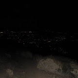
On the day of the climb, we were up at 02:45; out of the condo by 03:30 and at the Lyken trail head with our lamps on at exactly 04:30. The crystal clear view of cities below in the darkness of night was breathtaking. We made the Skyline junction by sunrise at 05:30 and packed away the headlamps. Being our first time on the Skyline trail, we took our time from this point. The climbing never really ended. There were hundreds if not thousands of short little switchbacks that each claimed another few feet of elevation. This is the mental kind of hiking where you just keep picking them up and putting them down, not long strides, but lots of short steps that don’t drain the muscles, but work the heart. We settled for lunch and a catnap on a big flat rock overlooking the valley at around 10:00am. It was at this point that I had consumed 100oz. of my water and shifted to a new source. We headed back up the trail at around 10:48 and once again resumed the zombie shuffle. Soon we could see the alpine zone in the distance, but it took many more hilltops to crest before we were actually on the fringe of the alpine zone. Coffman’s Crag looked close, but we knew differently. At least it was a landmark that would prompt our bid for the “Notch” when it was eventually reached. I was extremely happy to touch my first pine tree. Climbing in the alpine zone was challenging due to the new spring growth choking the trail. We reached the snow chutes prior to Coffman’s and did have some route finding issues. There was a lot of evidence of people scrambling for a trail. I can only say, use and trust your instrumentation, or backtrack to the known route and don’t budge until a proper route is identified going forward. The tricky part was that in some cases, the snow was only on the trail, masking the trail in some parts and in some cases masking a direction change. The most common mistake noted from all the tracks was that people were looking down when they should have been looking up for the next section of trail. After 45 minutes of route finding, we finally found the safe route to Coffmans, which had only been 1500 feet from our location. It is not a matter of knowing where you are, it’s a matter of finding a safe route from where you are to where you need to be. We reached the notch at 16:15 and were drinking root beer and Corona’s at 16:45. A quick tram ride down, a twenty-five dollar taxi ride and we were back at the end of Ramon road, in the Jeep on our way back home. Apart from the elevation of Mt. Whitney, this has been the most demanding of our adventures thus far.

Picture are located at the link below.


2010 05 12 Cactus to Clouds Hike


Information can be found at:


http://www.nationalgeographic.com/adventure/hiking/best-trails-andrew-skurka.html

and at:

http://www.geocities.com/cactus2clouds/skyline.html

Friday, February 12, 2010

Mt San Jacinto Peak Snowshoe Attempt 02/11/2010

San Jacinto Peak is located in the San Jacinto Sate Wilderness area located in the mountains that form the western and most prominent backdrop of the Palm Springs. The area can be accessed many ways, but is most often accessed from the Palm Springs Ariel Tram.

New to snowshoeing, but not hiking, we took a practice day in Long Valley two days before the summit attempt. Long Valley is also where the trailhead for the summit attempt would start. On summit day our plan was to take the Palm Springs Ariel Tram to the trailhead at 8,400 ft. and begin our attempt. The earliest tram up the mountain during the week is 10:00am. On weekends the first tram up is at 08:00 am. Wanting to avoid the crowds, we opted for the mid week start. This decision would certainly narrow our window of usable daylight.

On summit day, we arrived at the Mountain Station around 10:15. We descended the ramp from the Mountain Station to the short path leading to the ranger station in Long Valley. It is here where you fill out your wilderness permit, state your intentions and don your gear.

At the ranger station is where we made the decision that changed the fate of our summit attempt. There was a minimum of four feet of snow on the ground. A fresh foot of powder had just been deposited over the previous two days. The first person up any route would be blazing the trail for those who followed and also expending an enormous amount of energy. We quickly pondered this fact and talked with a group of snow boarders that had indicated they were making a dash for the summit in hope of boarding down the east face.

There are basically two routes up to the summit. The traditional route is via Wellman Divide and is about six miles. The Wellman route is fairly moderate for the first four miles and then ascends the last 1,300 ft to the summit via two long traverses in the last two miles. The direct route is basically a straight four-mile shot cross county that ascends the last 1,300 ft in .7 miles. This direct route ascends either the east face of Mt. San Jacinto “avalanche alley” or leapfrogs directly up Miller Peak and then on to the summit of Mt. San Jacinto.

The snow boarders were going the direct route, but they were taking the less dangerous Miller Peak route. The choice seemed obvious. We would follow the trail left by the mid twenty year old snow boarders, save ourselves two extra miles in addition to not having to break our own trail.

We set out behind the snowboarders at approximately 11:00 am. With this amount of snow, most normal obstacles to traditional hiking are covered. No roots to step over, no rocks to step over, just a smooth ascent following the rolling terrain to the base of our final destination. It was the last 1,300 ft ascent that ended out trip. At a quarter mile from the summit Ann hit the wall. I have seen Ann make the climbs up Mt Whitney and Half Dome. I know her resolve. This trip was different. The angle of ascent, the additional effort required to use snowshoes and the elevation had taken its toll. Ann trusts me to push her and to also protect her. To continue on would have placed her in danger. It was time to get off the mountain before she expended what little energy she had left to make the decent.

The young snowboarders had summited about an hour ahead of us. As we started our decent at 03:30 pm we saw them flying down the east face of San Jacinto Peak, oh to be young again. Descending on rubber legs, Ann took her time. The soft powder under the down hill snowshoe was prone to break away on each step down the mountain. Proper technique was critical. Two solid points of contact before moving was the mantra. Glissading with full packs and trekking poles in neck deep powder didn’t seem like an intelligent option. Once off the step mountainside, the trek through the valley was a pleasant change. It took us two and a half hours to reach the ranger station in Long Valley. We let the ranger know we were out and on our way to the tram. The ranger commented that we had arrived right at the edge of darkness. I related our trip to him, telling him we had headlamps. He asked if we had used our ice axes on the way down. I told him the snow was still too soft and that the axes and crampons were of limited use. We were the last ones off the mountain.

Ann was doing much better and we enjoyed a beautiful view of the illuminated desert floor as we descended on the tram. This had been a great trip. Sometimes you don’t reach your intended goal. The experience to where we turned back was epic. Today “our” summit was just a quarter mile from the geological summit. That was good enough for us.

Some photos of this trip can be found at the following link.

http://picasaweb.google.com/kBlogphotos/20100211MtSanJacintoAttempt?feat=directlink

Saturday, September 26, 2009

Mt Whitney - The Trip 9/18/09 - 9/21/09

This was a great trip. This was my second and my wife’s' first trip up Mt. Whitney. Four days this time as opposed to one day last year. These are some of the OK and the tracking points that record most of the Mt. Whitney trip. We started at Mt. Whitney Portal and hiked 3.8 miles to Outpost Camp at 10,450' on 9/18 and stayed overnight. We hiked 2.2 miles to Trail Camp at 12,000' on 9/19 and stayed overnight. We hiked 4.2 miles to summit at 14,497' and returned 4.2 miles to Trail Camp on 9/20. We stayed overnight at Trail Camp. We left Trail Camp at 12,000' on 9/21 and hiked 6 miles back to Mt Whitney Portal at 8,350'. At the Portal we had beer and cheeseburgers. The refreshments were priceless.

Both day hiking and backpacking have their advantages and disadvantages. Both require good weather. A day hike is a twenty-one mile round trip, which requires conditioning, a 10-pound pack, a wag bag for human waste and good luck. Luck with the weather and luck with altitude sickness. If either of these factors turns bad you should stop or risk your life and the lives of your party if you continue. Multiple days with overnight stays requires the conditioning to carry a 35-45 pound pack and gear to limit exposure to weather. Staying overnight allows time to acclimatize, in our case two days. Backpacking also requires you to use bags for lots of things. You sleep in a bag. You may eat from a bag. Lastly (in the Whitney Zone) you are required by law to poop in a bag, which you carry with you the entire trip. Collecting and carrying your human waste may seem extreme, but this area issues permits by lottery to up to 100 day-hikers and 60 overnighters per day in the high season. At the higher elevations there is nothing but granite. As you may imagine, granite is hard to trench and absorbs nothing. Rainwater and snow melt runs off the granite into the lakes used by hikers for drinking water. This should provide a clear enough picture.

You always want what you can’t have! When day hiking, you would love to just stop walking, you can, but then again, if you stop too long too often, it ceases to be a day hike. While backpacking you would love to shed 35 of the 45 pounds and give your feet, knees, shoulders and hips a break. Making and breaking camp each day is time consuming and not something you look forward to in the freezing temperatures found at elevation in the late evening or early morning.

Slow and steady has been the key to our success. The experience has been awesome in either case. A trip up Mt. Whitney is a memory that will never fade. You get tired, you think about stopping, but these are just temporary conditions, all things must pass, and these conditions are no exception. The celebration really takes place after the event, after it is over and you are home and have time to reflect on the entire experience without wondering if you will be successful.

Due to the nature of trip and equipment used to record the locations I will provide a link below. This is the first time I have used this new feature offered by the SPOT group. The pictures are not of the same quality as those that I have previously posted, but time and space are becoming an issue.

http://www.spotadventures.com/trip/view?trip_id=177981

Tuesday, September 15, 2009

Mt Whitney - last minute preparation

9/15/09

Things are shaping up nicely. Trained with full packs Monday, today just the usual 4 mile circuit and no complaints. There was a 30% chance of snow on the summit yesterday, that has passed and judging from the off shore breeze today, a nice high is building in the interior. Grabbing some last minute beverage choices, tea, powdered Gatorade, etc. Have enough Shot Blocks left over from the Yosemite trip. Water is heavy, we will carry just enough water to make it to known water. We will use a high volume pump to filter all water. We are taking 15 degree down bags for this trip with liners that add 15 degrees. Zero degree capability should keep even Ann warm. It looks like I will hit the trail with approx 43-45 lbs. and Ann with approx 33-35 lbs, this includes water and is not bad for five days, I was very pleased when the packs came in at these weights.

The weather forecast looks great for our visit. Outpost Camp Friday: Sunny, with a high of 69. Outpost Camp Friday Night: Mostly clear, with a low around 49. Trail Camp Saturday: Sunny, with a high near 58. Trail Camp Saturday Night: Mostly clear, with a low around 42. Summit Day Sunday: Expecting a high near 51. Trail Camp Sunday Night: Clear, with a low around 42. Outpost Camp Monday: Sunny, with a high near 68. Outpost Camp Sunday Night: Mostly clear, with a low around 49. The Portal Tuesday with a high near 68.

I did mention forecast? We will be ready for heavy rain and moderate snow if required, it is September. Yes, I hate to carry that stuff, but I hate more to need it and be without. That is one of the drawbacks of an extended trip, a sleeping bag, a tent, food, stove, and gear for weather extremes. When training to carry all this gear, you soon realize that you are probably at the same fitness level you need for a one day summit. That was last year, this year we hope to bask in the serenity and beauty without a deadline. Five days is more then enough time for a leisurely ascent, but does expose us to four more days of weather, regardless of the forecast. I'm still excited, but feel a sense of calm this year as compared to last, I hope that is a good thing. Anxiety is the main reason many well planned strenuous hikes get off to poor starts. Trust your gear, trust your training, trust your partner and trust yourself. This is going to be fun!

Whitney are weather can be monitored at:


The Mt Whitney web cam is working nicely and can be seen at:

http://www.whitneyportalstore.com/webcam/whitney_L.jpg

You can follow our progress on the SPOT adventures page:

http://www.spotadventures.com/user/profile?user_id=47808

Tuesday, September 8, 2009

The High Sierra Camps 9/2/09

9/2/09

Off to Tuolumne Meadows Lodge

We were up early, ate a hearty breakfast and were on the trail by 830 am. This last leg of our journey back to where we had begun, would start at 10,300 feet and drop to 8,600 feet in 7 short miles. The last day of most great journeys is always a little melancholy. We were occupied with thoughts about the whole trip, leaving new friends and yes, planning the next trip. This trip was no exception. Through conversations with camp staff and other guests we knew that the Yosemite fire was still burning far from containment and that our route out of the park west on 120 was still closed to traffic. This meant we would have to leave the park using the east entrance over Tioga Pass, travel north on 395 to 108 and come back to the west across the Sonora Pass adding 2-3 hours to our return trip to Escalon. This fact occupied our minds on the march from Vogelsang down Rafferty Creek to Tuolumne Meadows. We enjoyed the views of Rafferty Peak and Johnson Peak to the west, but having no camera, we paused very little. We made it to the car as marked on my GPS by noon.

This trip was one of great memories and great scenery. I love the High Sierra's and always will. I would like to make my gratitude known to the people that originally built the trails, those who built the camps and those who now maintain these jewels of the Sierras. I can't think of a more strenuous job then carving trails through high granite passes. I was pleased that in over 58 miles of hiking I found only one double A battery and one already disintegrating Kleenex. Good job people! Pack it in / pack it out works.

For those interested in the High Sierra Camps I have provided a link on this page. The slots are awarded by lottery as I may have mentioned earlier. You may get in late by looking for openings or cancellations on their web site. The options are endless. You do not have to do a loop. You can visit one camp for one night or multiple camps for multiple nights. I met a couple that was staying for 16 nights. You can stay at the backpacker’s camp, located at each camp and just pay for meals. And yes, you can still backpack the entire area without winning the lottery and still see the same sights; you will just have to carry your own sleeping bag, tent, cooking gear and food. I was warned that the park now requires backpackers to keep their packs in their tents, out of the view of hungry bears. I have not yet verified this rule / request.
You can see more details of this entire trip at this link.
To book a trip or find out about the camps use this link.

The High Sierra Camps 9/1/09

9/1/09

Off to Vogelsang HSC

Vogelsang is the highest of the High Sierra Camps at 10,300 feet. There are basically two routes that can be taken to reach the camp. The shortest is via Flecther Creek at just 7.6 miles and the longest is via Lewis Creek at 8.4 miles. We had from the very beginning planned to take the shortest route, but past visitors and camp staff urged us to take the mile longer and higher route due to the views afforded by the elevation. The higher route would allow us view Bernice Lake, Gallison Lake Meadow, Gallison Lake, Vogelsang Pass and lastly all the 12,000 foot peaks to the northeast. We didn't actually make the decision to take the high route until leaving camp and speaking with one of the mule team drivers as we left. Her last bit of encouragement was all it took and we had our plan.

We had already been the first .8 of a mile yesterday on our 6 mile round trip to Washburn Lake, so that was familiar territory. When we reached the junction that separates the two routes it was clear that the high route was named appropriately. It immediately headed steeply up the mountain and continued on for some time. Within the first couple of switchbacks I spotted deer just above and ahead of Ann. This was the second time I had spotted deer on the trip. I imagine deer had spotted us many times before, but had failed to tell us. This ascent finally topped out affording an outstanding view of Merced Lake. Now we headed directly into Lewis Creek canyon. The canyon was deep carved granite, heavily forested in areas, and the grade was manageable. We stopped near the summit where the meadow that feeds Lewis Creek opens up to a wide open view of the surrounding mountains and of course Vogelsang Pass. We ate our sack lunches while contemplating the climb over Vogelsang.

Lunch was good, we felt great, and had plenty of water. Water had never become a concern on this trip due to the abundant streams we had encountered. Even in August there is adequate water in the High Sierra's. We crossed the meadow leading to the trail up to the pass. We scurried across a couple moderate water crossings and hit the mountainside at our usual pace. Yes it was steep, never dangerous and the views were out of this world. We stopped a couple times, once to listen to a small babble of fresh water pouring from the rock just feet from the trail on this steep mountainside. The trail is deceptive; it starts below a peak that is much higher then the actual pass. If you approach under the premise that the trail continues to the peak you will quickly be defeated. Once you have gained an elevation equal to that of the actual pass you traverse south west for a long distance and emerge at the much welcome opening known as Vogelsang Pass to a beautiful meadow on the northwest side of the summit. It was here that we met Rick and James. We found them sitting at the summit, taking in the view. We learned that they were Cal Poly grads and spoke with them for some time before they headed off to the camp, which was on the far side of the lake in the distance. It was all down hill from this point forward and as a matter of fact for the bulk of the remaining trip.


Leaving Merced Lake. These guys are a great way to travel, you watch the sights, they watch the trail, maybe someday we'll try it.

We have already gained enough elevation to view Merced Lake in the distance.

The cross roads. Today we take the high road. Vogelsang Pass here we come.

Check the sign just to be sure.

Ann with a deer proceeding her up the switchbacks.

I can only call this a sheet falls, nearing the meadow where the real climbing starts.

Nice place for lunch, to bad we had already eaten, we crossed the two logs on the lower right.

That is where we are headed. Must go through the pass to reach the camp.

Last of the comfortable meadow hiking.

We start our ascent of Vogelsang Pass.

Ann making her way upward.

We are near the top now. Can you see the small lake in the meadow off in the distance?

A victory photo from Vogelsang Pass.

A victory photo from Vogelsang Pass.

As you crest the pass, the other side opens to a beautiful meadow.

Ann was right. Had I been right we would still be climbing.


Arriving at Vogelsang HSC

We followed the well-defined trail along the high meadow skirting Vogelsang Lake. The lake was amazingly clear and the bottom was clearly visible in many locations. The lake held a small rock island that just called for a high mountain swim. This was a swim that I may regret not taking, but I didn't want to test my shock tolerance at 10,300 feet. We entered the camp around 3 pm. It was beautiful and nestled right at the foot of 11,407 foot Fletcher Peak. There were just a few tent cabins and a stream went within 8 feet of our cabin #2. This camp, like all the camps except Merced Lake had little wood stoves in each cabin. At this elevation I checked the wood supply and Ann checked the blankets. It was a three-blanket camp, three wool blankets and a comforter on each bunk; it would be cool this evening. We immediately explored the area taking pictures until my last battery called it quits. The call for hot drinks soon came and all guests filtered in, dressed a little more warmly then they had in the past. The smell of dinner permeated the mountain air. Tonight would be a choice of ravioli stuffed with beef or mushroom. The evening was delightful as we ate well and shared our experiences of the day. Virtually all of those in camp tonight were leaving the next day. We wished our friends well and prepared for a chilly night and an early departure to Tuolumne Meadows in the morning.


The meadow trail leads to Vogelsang Lake, the camp is on the far side.
If you enlarge this photo, you should be able to see some tent cabins on the far shore.
Ann crosses her last water hazard!


The Vogelsang High Sierra Camp and the last of my camera battery!

The High Sierra Camps 8/31/09

8/31/09

Second day at Merced Lake HSC

Merced Camp was big, we had the tent cabin to ourselves for two nights. After a leisurely breakfast and completing the chores of laundry we pondered our options. There were many places to explore and the lake itself was inviting. We decided to take a walk up the canyon following the headwaters that fill Merced Lake. The name of the trail was Washburn Lake, it was just three short miles, but we had elected to travel only to the ranger station at .8 miles and return. It is like buried treasure in the Sierra's, once you have seen a little you have to see more, there is no going back. Ann said I tricked her, but her resistance was feeble. We enjoyed a very slow stroll up to Washburn Lake, taking in all the sights along the way. The forest floor was covered with pinecones, there were small picture perfect trees amongst the giants, it was perfect. Water falls and colorful mineral outcropping all along the trail. Hungry squirrels waiting for the sound of a green pinecone to hit the ground. When a cone fell as one did on many occasions, it was carved to the core in minutes as the squirrel collected the fresh pine nuts. A sheer ledge cut into the granite guarded the entrance to Washburn Lake. We sat on the leeward shore enjoying the view and the solitude until a chilly breeze that whipped up small wind chop drove us back toward Merced Lake and the sunny confines of camp. We were hungry, the trip in to Washburn had taken about two and a half hours, the trip out took just an hour and a half. We were hungry!

Upon arriving at camp we ate the sack lunches that would have been perfect at Washburn Lake. What we had intended to be a stroll had turned into a day hike. We had taken nothing but our hiking poles. This is perhaps why day hikers are rescued more often then overnighters in the wilderness. The day hiker never plans to spend the night, run out of food, water, or suffer nighttime temperature extremes. What you plan for and what actually happens can quickly become the difference in a one way or a round trip ticket. We were merely inconvenienced. We were lucky.

Ann and I had finished our sack lunches and were hanging around the dinning tent enjoying the afternoon sun. I had just poured my third glass of lemonade when some type of a commotion broke out. I was totally disinterested, but Ann kept calling me over to see the commotion. I followed her to the outside edge of the eastern row of tents just in time to see the cute little bottom of a black bear jump a log and turn to see if his antagonist was still in pursuit. The camp manager was not far behind yelling for him to "get out, go on, get moving". Black bears are common in Yosemite; they are just not seen that often. To see one in the wild was terrific. They will usually always back down to aggression and kill rarely. A bear has never killed a human in Yosemite, but a buck has killed a young boy. The deer’s hove puncturing the boys chest and damaging his heart. Deer are far more dangerous then bear due to their numbers and their frequent contact with humans. All food and toiletries are to be stored in food lockers; anything with a scent the bear may find inviting should be locked up. I was told that backpackers are now asked to keep their packs inside their tents to break the pack/food association that some bears still maintain.

Well needless to say the bear sighting was a great topic at dinner that evening. We had a fine chicken feast, played cards and retired early. Thoughts of our ascent to Vogelsang Pass and maybe a little wondering if our furry buddy would return in search of a midnight snack were the last of the night.


Relaxing around camp, don't forget to check out the small things.


Just a few pedals short of a full flower.


Have you ever waited for an ant to stop moving, even for just a moment?


A teenager standing with adults.


They sent this little guy out to clean up all the pinecones.


Ann's eye for berries.


Thistle's don't have to always have to be a nuisance!


Do you think she thinks we are on a little stroll?


Washburn Lake, beautiful but windy on this afternoon.