Ann and I had been researching and planning this trip since we learned of its existence a few years back while hiking in the Palm Springs / Mt. San Jacinto areas. There are few trails that can take you from the Sonoran Desert zone to the Artic/Alpine zone in 11 miles. This is only possible due the 8,000 feet of elevation gained on this trail in such a short distance. The scenery along the way and the views from all points along this trail make it one of my favorites. One of the other enticing factors of this trail is that you only have to hike up, the tram will take you down if you can make it to the top. The trail starts at either the north west corner of the Palm Springs Art Museum parking lot or at the end of Ramon road as is terminates in the foothills. The museum start is much steeper, the Lyken trail from Ramon road is a little longer but easier on the legs. These short entry trails both meet at the Skyline trailhead above the Art Museum. This trail is as difficult as it is beautiful. There are four factors that must not be ignored to make a successful climb. (1) Fitness, you must be able to walk 11 miles climbing 8,000 feet in 8-12 hours. (2) Dehydration /Heat, you must carry at a bare minimum one gallon of water. (3) Route finding skills, you must have basic route finding skills down solid. (4) In the early spring, snow on the ground may cover many parts of the trail. A lot of frozen snow (ice) in the chutes will make crossing dangerous with out crampons and ice axe. Without this equipment, your chance of an un-arrested fall could end in your death. If any of this scares you, I have made my point. Realistically there are only two times of year the Skyline / C2C should be attempted. The snowless cool early fall and the snowless cool early spring. The first four fifths of this trail is without canopy in the open sun. To attempt this trail in the summer is not sane. I do not believe enough water can be carried to sustain a dayhike in the summer months. Due to the number of rescues performed this year, Ann and I rode the Palm Springs tram to the top and hiked down from the “Notch” where the trail ends in Long Valley to a little below Coffmans Crag, where most of the rescues had taken place. We took this exploratory hike to access conditions we would find as we ascended from the desert floor. We encountered some snow, but nothing that required special equipment. The snow that remained, although thin and unfrozen did cover parts of the trail that would have to be negotiated. We left some trail markers and we returned to the “Notch”. During this assessment hike we met a gentleman who was just completing his ascent. We asked him about the conditions and he said the trail was fine if we exercised good route finding skills and took our time. He had crossed snow that we had not reached without too much difficulty. He also said the that very next day would be the best time to go due to the lower temperatures and that it was only going to get hotter as the week continued. This information tipped Ann to the lets go side of the scale. We thanked him for his time, headed back to the tram and back to our home to pack and prepare.
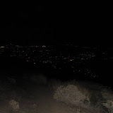
On the day of the climb, we were up at 02:45; out of the condo by 03:30 and at the Lyken trail head with our lamps on at exactly 04:30. The crystal clear view of cities below in the darkness of night was breathtaking. We made the Skyline junction by sunrise at 05:30 and packed away the headlamps. Being our first time on the Skyline trail, we took our time from this point. The climbing never really ended. There were hundreds if not thousands of short little switchbacks that each claimed another few feet of elevation. This is the mental kind of hiking where you just keep picking them up and putting them down, not long strides, but lots of short steps that don’t drain the muscles, but work the heart. We settled for lunch and a catnap on a big flat rock overlooking the valley at around 10:00am. It was at this point that I had consumed 100oz. of my water and shifted to a new source. We headed back up the trail at around 10:48 and once again resumed the zombie shuffle. Soon we could see the alpine zone in the distance, but it took many more hilltops to crest before we were actually on the fringe of the alpine zone. Coffman’s Crag looked close, but we knew differently. At least it was a landmark that would prompt our bid for the “Notch” when it was eventually reached. I was extremely happy to touch my first pine tree. Climbing in the alpine zone was challenging due to the new spring growth choking the trail. We reached the snow chutes prior to Coffman’s and did have some route finding issues. There was a lot of evidence of people scrambling for a trail. I can only say, use and trust your instrumentation, or backtrack to the known route and don’t budge until a proper route is identified going forward. The tricky part was that in some cases, the snow was only on the trail, masking the trail in some parts and in some cases masking a direction change. The most common mistake noted from all the tracks was that people were looking down when they should have been looking up for the next section of trail. After 45 minutes of route finding, we finally found the safe route to Coffmans, which had only been 1500 feet from our location. It is not a matter of knowing where you are, it’s a matter of finding a safe route from where you are to where you need to be. We reached the notch at 16:15 and were drinking root beer and Corona’s at 16:45. A quick tram ride down, a twenty-five dollar taxi ride and we were back at the end of Ramon road, in the Jeep on our way back home. Apart from the elevation of Mt. Whitney, this has been the most demanding of our adventures thus far.
Picture are located at the link below.
Information can be found at:
http://www.nationalgeographic.com/adventure/hiking/best-trails-andrew-skurka.htmland at:
http://www.geocities.com/cactus2clouds/skyline.html